
Image: Tupaia’s Map March 23, 2011
Author: Beach Combing | in : Modern , trackback
History faculties have spent much of the last forty years demonstrating to their own satisfaction that the rise of the West is not ‘the whole story’. Hiding behind enslaved Africans, small-poxed Carribean islanders and various downtrodden Asian peoples there are other narratives struggling to get out. Beachcombing is all for looking at the other side of the coin. But he is often irritated as so much of this is wishful-thinking and self-flagellation rather than hard, cold facts: the Black Athena, among many, many others comes to mind.
How refreshing then when some genuine antidotes to Western arrogance come along. And as yesterday Beachcombing was harping on about islands he thought that today he would turn to Tupaia’s map of the Pacific.
Tupaia was a noble member of the arioi sect who Captain James Cook picked up on Tahiti in 1769. Tupaia, in fact, enlisted on Cook’s ship to escape from disagreements on Tahiti itself: he had found himself on the wrong side in a tribal war and had also been sleeping with the chieftain’s wife, Purea. This being Tahiti sleeping with the chief’s wife was not that serious but still… It wasn’t necessarily conducive to a long life.
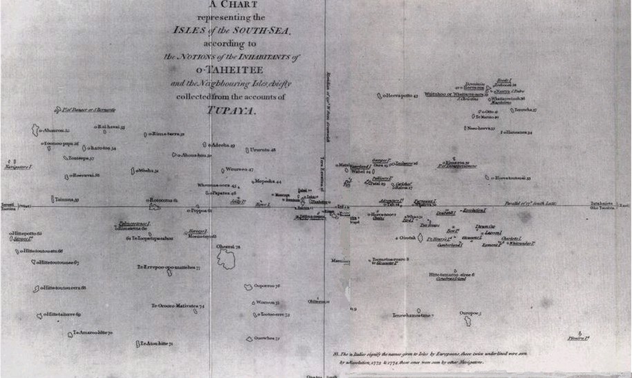
Tupaia would die in 1770 at Jakarta on his Majesty’s service, but before he did so he became a valued member of the crew, proving himself to be a useful diplomat – he could communicate with many Pacific peoples including the Maori and, above all, a brilliant navigator. It was, in fact, as a navigator that he was remembered by Cook who included this map of the Pacific islands drawn by Tupaia in his documents.
It is not a map that Ordinance Survey would recognise. At the centre of the universe is Tahiti (of course), Tupaia’s adopted home. The Easter Islanders believed that they were at the centre of the universe, Londoners have a similar delusion (GMT), so why shouldn’t the Polynesians? Then the other Society Islands – including his home on Ra’iatea are spread out in the seas around and islands some two thousand kilometres distant are included. Indeed the map covers an area of a thousand plus kilometres by about three thousand.
Of course, there is no question of this map being ‘to scale’ in any normal sense of the word. What is fascinating though is that this was a transposition of the mental map that Tupaia as a navigator carried around in his head: and the distances take currents and winds rather than miles and yards into account.
Polynesian civilisation would barely survive the coming apocalypse of Western settlement and exploitation. And yet Tupaia’s map is a reminder of that now lost thalassocracy of peoples sprinkled across the Earth’s most beautiful ocean.
Beachcombing is always on the look out for striking historical pictures and photographs: Drbeachcombing AT yahoo DOT com

