Guest Post: Walking the Pennine Way in 1965 April 22, 2015
Author: Beach Combing | in : Contemporary , trackback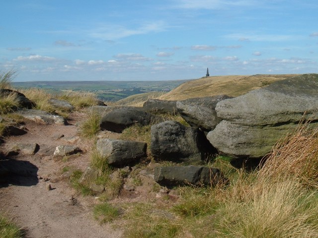
This guest post sets out the experiences of one of the first walkers on England’s best long-distance trail just after it had opened in 1965.
I still keep one bit of kit in my rucksack that goes back to my 1965 trip up the Pennine Way. It’s a small blue, plastic container with a cracked, click-on lid. I kept sugar in it for hot drinks. But now it holds nuts and raisins, & it still triggers memories. It was an absolutely wonderful time. The weather was fairly kind, I camped as I went, there were curlews all the way, the people were fun, and I discovered that ‘The North’ is many places. I’ve lived and loved and worked in and around the Pennines ever since, and I still find I’m aware of the PW route when driving into the hills.
I’d left school in March & got a temporary job ahead of university. During the media coverage of the official opening in April, my mother suggested that I tackle it. Exploring all those hills really appealed. I had been brought up amongst the rolling Downs of Surrey & Sussex. Leith Hill seemed huge to me. But as I grew up, the photos of Snowdonia, the Lakes and Skye around the house increasingly seemed to emphasise its limitations. A scout camp in the Lakes, and walking in the Mountains of Mourne had introduced me to the excitement of being higher up. Climbing Ben Nevis with my Mum had been the real eye-opener. And, besides, I had a very secret secret. Wuthering Heights had been much the most exciting book I’d ever read, and I wanted to see, and to feel where Catherine and Heathcliffe had lived. So I started to save; bought a rucksack, a tent, a sleeping bag and some cooking gear; rubbed meths into my feet; and hitch-hiked up to Edale.
It all seems a bit mad now! Would you let an eighteen-year old go off like that? When I said this to my wife recently, her response was “It’d depend on how much you wanted to be shot of him”! My father huffed and puffed. Sending a postcard every day didn’t seem much to worry about.
Maps were the most interesting and useful thing I’d encountered at school. I’d learnt to use them exploring the Surrey hills on foot and by bike. I became even more fascinated with them during a Duke of Edinburgh’s type expedition around the Brecon Beacons. But navigation is always easier in small groups. Needless to say, my over-confidence was revealed on the first day as my compass skills were tested to destruction: crossing Kinder from the top of Grindsbrook I found myself seriously off-course down the road towards towards Sheffield. Thereafter I took more care when seeing, on the old 1” to the mile maps, that worrying phrase on the route ahead – ‘Pennine Way undefined’. I don’t remember many signs, let alone boarding or stone slabs along the paths.
Buying maps emerged as a problem. I had the first, but the Information Centre at Edale was sold out of the ones further north &, on June 27th when I started, the guy said he had no leaflets left. I bought Ken Oldham’s Pennine Way book – for six shillings (30p). This proved great on background, but not on detail. It was encouraging though, to know that the hardest bit was the first three or four days. I walked, hitched and bussed down into Huddersfield and back. I got several in Middleton, and I remember weighing my rucksack on a machine outside the general store in Alston. It was 42 lbs – about 19kg?
At the back of Ken Oldham’s book I’ve written the distances I walked each day. My camping sites are marked on the route maps, but the precise spots remain largely a blur. I can only summon up a picture of three of them.
One of my most vivid memories is relaxing after a snack by the Blackstone Edge trig point; looking out over Manchester; and gradually becoming aware not just that the sky was darkening; but that the storm was actually aiming straight at me. It was the first time I’d felt threatened in the hills. Down on the road I met a local guy who explained that as the reservoir road was very exposed, he was walking back down Cragg Vale. Years later I used to commute up and down that road, stopping occasionally to follow the PW north to Stodley Pike. That afternoon we chatted as we went down, and I rejoined the Way via Withens Clough. I camped at the top farm below Stodley Pike. The hill-farmer smiled and said, “Aye lad, it’s nobbut ten minutes tut pub down yonder”. It proved my introduction to West Riding under-statement.
Years later after my Mum had died, I found she had kept the postcards I’d sent. I had been surprised by how long it took me to set up every night, and get everything back into my rucksack each morning. But Malham Cove; the athleticism of the sheep on Penyghent; and the woods and waterfalls along the Tees all impressed me. Catherine had remained a secret – but I certainly remember my first of many visits to Top Withins. I couldn’t put it into words, but I came much later, to understand it in terms of DH Lawrence’s ‘spirit of place’. The cards have some interesting bits too: I don’t remember boiling eggs while simultaneously floating a teabag.
I shall never forget my slog across the Cheviots. It was raining when I left the road: “fog, rain, slush, hail and bog” I wrote. I camped at 1750 feet below Beef Stand; heated a curry; and feasted on cheese and milk chocolate digestives. Over the years since, I’ve occasionally shut my eyes, and indulged myself in this strange comfort food. It was still raining when I reached the first farm the next evening. The farmer took one look, and ushered me into a haybarn. I’d never been so wet in my life, and I slept till lunchtime the next day. It’s that sleep I remember, not arriving at Kirk Yetholm.
Years later in retirement, I redid the whole Way in 4-5 day chunks while using B&Bs. It was only then that I enjoyed the wonderful views along that roller-coaster stretch. My journal from that day goes into ecstacies.
Looking back, the experience shaped my lifelong interests in both the environment and wildlife, helping to divert me away from teaching history, which was where school and my father had been steering me. In the late 1960s the controversy about building the Cow Green Reservoir erupted, and I vividly remember standing in a student bedsit when I heard the news on the radio that it was going ahead. On one card I wrote “the birds are incredible. I do wish I had someone with me to tell me all”. It’s the curlews that I mainly remember, while others like the wheatear, as revealed by the slightly weird descriptions on the cards, were quite new to me. The slow flapping Short-Eared Owls seemed quite magic.
I really caught the walking bug too, led on in exactly the way that Tom Stephenson had suggested in his 1935 article – “to explore every corner of this lovely island”. In 1967 I walked up the coast from the Wash to Berwick while taking in some of the N Yorks Moors. In 1968 I started at Exmouth and followed the coast round to the Lizard. Lots more exciting bird discoveries! Since, I’ve walked in all the English National Parks, been high in the Hebrides and in the Pyrenees, and tackled some Scottish mountains. But it’s always the high hills of the North of England that pull me back. So, thanks Mum – great suggestion!
Essentially, walking the PW either alone or in a group, is a self-centred challenge with many highs and lows. Hopefully it provides pleasure and achievement, and a great sense of freedom. It’s that line in The Manchester Rambler: you’re a “wage slave on Monday, but a free man on Sunday” – yet you get nearly three weeks!
My most memorable day began at Horton, took me up onto the Roman Road with its wide views and over to Hawes. I felt so good after I’d had a meal that I carried on up and over Great Shunner Fell, and down to Thwaite. It was the first time I fully experienced that feeling of elation and joy that can come from being high up. Somehow, it can give you extra energy. It’s summed up for me by Martin Carthy’s line about “You drink and you drink till you’re drunk on the joy of living”.
The postcards offer a corrective: it was raining when I put the tent up at 10pm at a farm on the edge of the village; I’d got my first and only blister; and the cost was sleeping late and not starting till noon the next day. But it is the memory that remains, of discovering that special joy of being high in the hills. It led on to having favourite places; to my continuing search for ‘the roof of the North of England’ – those spots with the best all-round 360 degree views. Part of this is the excitement of looking all around, picking out past and possible future routes; and to wondering what lies beyond the horizon. Sharing all this with others, and finding they ‘get it’, has become an added pleasure.
Putting something back, as the demands of work and family slow down, has been interesting and rewarding. Along the PW, and near to it, from Black Hill to Stodley Pike, I collected bird records for the British Trust for Ornithology’s Bird Atlas 2007-11 project, and I’ve since contributed records to other surveys around Black Hill. Being up there early on a spring morning gives you quite different perspectives from when you’re trudging through peat with a heavy rucksack. Encounters with mountain hares are a real treat. In winter they’re white against the black peat; and in summer they leap, all brown, through the snowy white cotton grass. I spent 3 months one winter playing a very small part in the peat restoration work at the RSPB reserve on the western shoulder of Black Hill. When le Grand Depart came through in July 2014, people were wearing open-toed sandals on the top. After all Wainwright’s complaints about the black peat up there, surely he would have smiled at that.
But what really matters now, fifty years on, is not the personal, but the broader context. On the North side of Kinder as you approach the Snake Pass, there has been for many years now, a fine easy path of stone slabs. Bouncing along, it feels as if you are walking down Oxford Road in Manchester or up the Headrow in Leeds. These great slabs have been dug up from the floors of derelict textile mills in the towns that grew either side of the Pennines in the 19th century, and recycled for a new use in the post-industrial age.
They symbolise the wider significance of the Pennine Way in the history of the great outdoors. After centuries of Enclosure Acts, the failure of the early Access to the Mountain Bills of 1884, 1908 and 1926 ran in parallel with the first mass trespasses – on Winter Hill above Bolton in 1896, at Winnats Pass in 1927 and on Kinder in 1932.
The creation of the Pennine Way in 1965 subsequently provided a giant stepping stone between the achievements of the late 1940s with the legislation for the National Parks, ANOBs, and subsequent events. It led on to the emergence of other long distance paths; to further trespasses at places like Alcomden Stones near to Top Withins in the 1990s; and on to the great achievement of the Right to Roam.
We are all indebted not just to Tom Stephenson, but also in fairness, to many others – the campaigners and writers he inspired; the bureaucratic fixers and route finders who worked for years to make it happen on the ground; and the volunteers and activists who trudged through committee work and mended stiles on the management and maintenance side.
The Pennine Way helped take us all the way – from mass trespass to Open Access.
Beach thanks Stephen Young for this piece, youngcountryside AT hotmail DOT co DOT UK Beach would be glad to put up other memories of the PW drbeachcombing AT yahoo DOT com

