
Thirteenth-Century Eurasia April 8, 2017
Author: Beach Combing | in : Medieval , trackback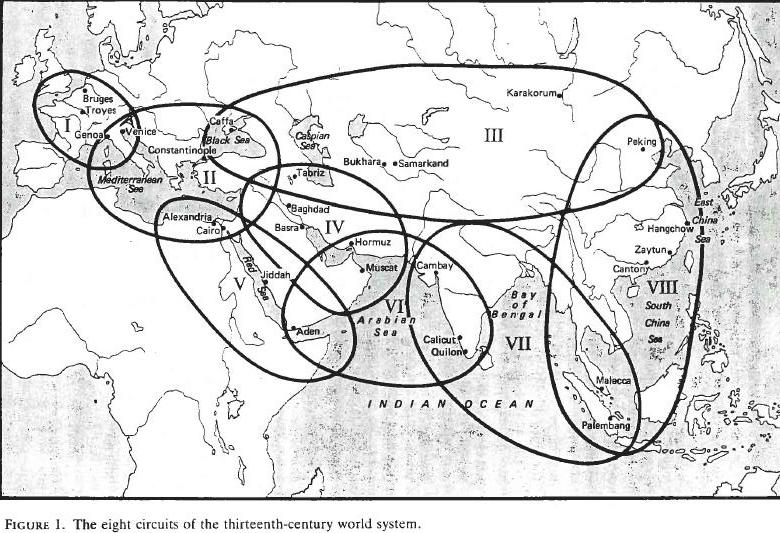
In 1989 Janet Abu-Lughod published her Before European Hegemony. In a series of graphics and discussions she attempted to map out not the trade routes, but the trade zones (‘trade circuits’) that divided up Eurasia and, indeed, Africa to the north of the Sahara and down the Horn. As with many bold economic books, these graphs cannot really be said to be based on empirical data: they are more the impression of a learned individual who immersed herself in the sources, both textual and archaeological. In other words these circles are remarkably crude approximations of what were probably realities on the ground: we must presume that: (i) they were changing all the time – something JA-L herself is at pains to emphasize; (ii) that some goods did not conform to these trade zones, stepped outside them or were confined to relatively small areas within them. Still it is remarkable to think of Beijing in the same quadrant of influence as Constantinople where Seres merchants would meet Franks and Vikings; or to think of Sri Lankan traders working quite naturally in the far Pacific and bringing goods back to sell to Africans and Arabs. The absence of trade zones over large parts of this map is annoying, but reflects the real fact that trade was insignificant through much of these lands. However, in the thirteenth century it is worth remembering that the Norn-speaking inhabitants of northern Scotland were part of their own mini trade world that stretched as far as the coasts of Labrador to the north; that Baltic merchants still traded into the Black and Caspian Sea; while the Muslim inhabitants of Hispania were connected to distant Nigeria. Any wrong place objects should be placed in this kind of continuum. What strikes Beachcombing looking at these maps is actually how few trade zones most crafted objects cross. For example, Roman glass made in Syria that turns up in Japan, has crossed three. Very little goes further through straightforward trade save raw materials.
Other maps of early world contacts: drbeachcombing At yahoo DOT com
30 Apr 2017, Bruce T: those zones have held up remarkably well for being nearly 30 years old [Bruce spot on here]. Some corrections are in order. The Mongols held territory from to the Pacific shores of what is now the Russian Far East and Korea, in what is her Region III. Her Region VIII is bit expanded to the S.E., however we now know much more about the Malay thalassocracies and their impressive range and seapower, checking the Chinese from trading directly with the Spice Islands on any sort of regular basis. Regions V, VI, & VII along with parts of VIII were engaging in trade in more or less holistic system based on the moonsoon winds from Southern China to Mozambique and Madagascar. Malay sailors had long been making the straight shot across the Indian Ocean to the East African coast, and the peoples of India, Persia, South Arabia had been riding the monsoons since antiquity along with the traders of the Red Sea and Somalia, and by the 12th century the Swahili states along the East African coast. Perhaps, we should move the Indian Ocean and South China Sea into a single economic zone dominated by the powers that held choke points on the edges? The Malay States at Straits of Malacca and the Sunda Strait, the Yemeni’s and Somali’s at the mouth of the Red Sea, the Omani’s and the Persians at the mouth of the Persian Gulf, and the Indian states of both the Malabar Coast and the extreme south of the subcontinent, along with Sri Lanka, rich trade centers, and the natural weigh points to sit out the monsoon if you got a late start hauling your goods either way. The three and the s. extremeties of VIII, combined into a single trading system that stretched from the Spice Islands on the fringes of New Guinea, to extreme S. Mozambique, to the head Red Sea and Basra at the head of the Persian Gulf, to Guangzhou in S. China. and all points in between. There are plenty of maps of trade routes in that period, Beach, as you well know. Google will take you right to them. Try www.rogerblench.info for the Indian Ocean and East African trade. He’s a Cantabrigian prof who isn’t afraid to go outside the box and will move on to other options when his hypothesis’ come up short.

